On this coast, conditions are not background — they are the primary variable. Two degrees of surface temperature or a change in swell period will decide a day more reliably than any report will. This page describes the data West Coast anglers actually use and points at the public sources that publish it, all of which are free.
Sea Surface Temperature and the Break
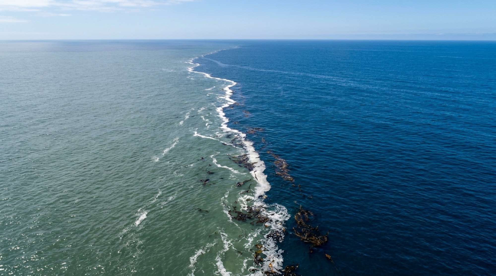
Sea surface temperature is the single most watched input in West Coast offshore fishing. The reason is not the absolute number but the gradient: where two water masses of different temperature meet, a boundary forms. Bait accumulates along it, predators work the edge, and floating debris and kelp collect there. That boundary is a temperature break, and finding it is most of offshore fishing here.
Breaks move — sometimes many miles overnight — which is why imagery has to be current to be useful. Satellite passes are also defeated by cloud, so a stretch of overcast can leave anglers guessing for days. Historical and near-real-time imagery for this coast is published through NOAA CoastWatch.
Colour matters alongside temperature. Warm water is typically bluer and clearer; cool coastal upwelling is greener and more turbid. Experienced anglers read the colour change as a proxy for the break when imagery is unavailable, and a visible edge of clean blue against green water with a foam line and floating kelp along it is one of the most reliable signals in this fishery.
Buoy Observations
Offshore buoys report wave height, dominant wave period, wind speed and direction, air pressure and water temperature, updated continuously. For planning purposes they are more useful than a forecast, because they are measurements rather than predictions, and because the pattern across several buoys shows what is arriving before it arrives.
Wave period deserves more attention than height. A four-foot swell at eighteen seconds is a long, smooth, ocean-crossing groundswell and a comfortable day. Four feet at six seconds is short local wind chop and a genuinely unpleasant one. Anglers who read only the height number regularly misjudge conditions. Observations are published by the National Data Buoy Center.
Tides
Tide governs the inshore fishery far more than the offshore one. Moving water concentrates bait against structure and triggers feeding; slack water usually turns fish off. What matters is not high or low but the rate of change — the middle of a large exchange is generally more productive than either extreme. Large spring exchanges around the new and full moon move more water and can improve inshore fishing while making some areas harder to fish safely.
Official predictions and real-time water levels come from NOAA Tides and Currents, and the general mechanism is explained plainly in NOAA's ocean service material.
Wind, Swell and Forecasts
Wind is the practical limiting factor for private boaters. Afternoon wind is a near-daily pattern along much of this coast, which is why so much fishing happens at dawn. Combined swell — where a long groundswell and a short wind swell arrive from different directions — produces confused seas that are worse than either component alone, and forecast products break the components out for exactly that reason.
Coastal and offshore marine forecasts are issued by the National Weather Service and are zone-based, so the right zone matters as much as the right day. Regional offices publish local discussions that are often more informative than the raw forecast, and tropical systems moving up from the south — occasionally relevant to the Baja end of offshore trip planning — are tracked by the National Hurricane Center.
Climate-Scale Signals
Over seasons rather than days, El Nino and La Nina conditions reshape this fishery substantially. Warm phases push tropical species far north and can produce extraordinary local seasons while suppressing the cold-water fishery; cool phases do the reverse and generally strengthen upwelling and the inshore bottom fishery. The current state of that oscillation is published by the Climate Prediction Center and is worth checking once a season rather than once a week.
Putting It Together
The method that has worked on this coast for decades is unchanged: establish where the productive water is from imagery and buoys, confirm it against recent local reports, and adjust with whatever real-time reports are available on the day. Conditions first, reports second. Reports describe yesterday; conditions describe now.
Note. An independent reference. Not affiliated with, endorsed by or connected to the AllCoast fishing community at allcoast.com, nor with any landing, sport boat, tackle company or publication described here. Nothing on this site is bookable, purchasable or joinable, and nothing here is regulatory, safety or navigational guidance.